K2E-B-N2-5 · Paper Note
MapEx: Probabilistic Information Gain from Global Map Predictions
- Description: MapEx paper note — indoor exploration that scores frontiers by probabilistic information gain: an ensemble of LaMa inpainting nets predicts the global map, a probabilistic raycast estimates what a viewpoint can actually see, and the gain is the predicted-map variance inside that visibility mask; +25.4% over nearest-frontier and +12.4% over map-prediction baselines on the KTH floor plans (ICRA 2025)
- My Notion Note ID: K2E-B-N2-5
- Created: 2026-07-19
- Updated: 2026-07-19
- License: Free to share: please credit Yu Zhang and link back to yuzhang.io
Table of Contents
- 1. Summary
- 2. Key Contributions
- 3. Method
- 4. Experiments & Results
- 5. Ablations
- 6. Strengths / Limitations / Future Work
- References
1. Summary
Title: MapEx: Indoor Structure Exploration with Probabilistic Information Gain from Global Map Predictions Authors: C. Ho*, S. Kim*, B. Moon, A. Parandekar, N. Harutyunyan, C. Wang, K. Sycara, G. Best, S. Scherer (CMU Robotics Institute; BITS Pilani–Goa; Brown; U. at Buffalo; UTS) Paper: arXiv:2409.15590 (ICRA 2025) Github: castacks/MapEx · project page
MapEx — frontier-based indoor exploration that decides where to go next using a probabilistic information gain computed from predicted maps.
Core problem: Indoor environments are structurally predictable (repeating rooms, corridors), but classical frontier exploration ignores this and falls back on heuristics like "visit the closest frontier first". Learning-based methods that predict the unknown map improve on this but each fails in one direction:
- IG-Hector scores a viewpoint by predicted sensor coverage -> highly sensitive to map-prediction quality.
- UPEN goes toward high map-prediction uncertainty -> ignores sensor coverage/visibility, so the "gain" doesn't reflect what the sensor would actually acquire.
Key insight: reason jointly over what the robot can observe (coverage) and how uncertain that region is (variance). Either signal alone is misleading; their combination is the useful one.
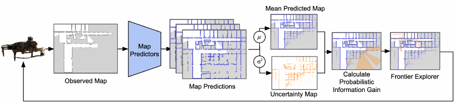
Approach (4 steps): predict a global map from the observed occupancy grid with a LaMa inpainting network -> estimate uncertainty as the pixelwise variance of an ensemble of predictors -> estimate a viewpoint's visibility with a probabilistic raycast over the mean predicted map -> information gain = sum of variance inside that visibility mask. The gain becomes a frontier score in an otherwise classical frontier explorer, so planning stays long-horizon and needs no learned planner.
Main results: on the real-world KTH floor-plan dataset, averaged over coverage / predicted-map IoU / topological understanding, MapEx beats nearest-frontier by 25.4% and map-prediction baselines (IG-Hector, UPEN) by 12.4%. Its explored maps are also more useful for downstream path planning.
2. Key Contributions
- Probabilistic sensor model as an information-gain metric — predicted maps are used to form a probabilistic model of what a viewpoint can see, rather than a deterministic coverage estimate.
- Joint coverage + uncertainty reasoning — the gain multiplies "will I see it" against "is it uncertain", fixing the complementary failure modes of IG-Hector (coverage only) and UPEN (uncertainty only).
- Global (not local) map prediction — prior work predicts local patches; MapEx inpaints the whole map, enabling long-horizon global planning.
- Drop-in frontier score — the metric plugs into classical frontier exploration, so no planner needs to be learned.
- Topological Understanding (TU) metric — a new evaluation that measures whether the explored/predicted map is actually good enough to plan paths on, not just pixel-accurate.
3. Method
3.1 Problem Setup
2D environment ; robot state on a diagonally-connected grid; a 2D LiDAR of range returns evenly spaced rays over . Pose is assumed known and noise-free, as are the range measurements. The robot accumulates measurements into a top-down observed occupancy map with three labels (0 = free, 0.5 = unknown, 1 = occupied) and acts until a time budget . Grid resolution: 1 pixel = 0.1 m.
3.2 Global Map Prediction
A global prediction module completes the unknown regions:
= observed occupancy map, = complete predicted map. is LaMa (a large-mask image-inpainting network built on Fourier convolutions — chosen for its large receptive field and global context, which suits maps with big unknown areas). The occupancy grid is treated as a 2D image and unknown cells as missing pixels. LaMa's off-the-shelf Places2 weights are fine-tuned on KTH floor plans using (observed map, ground-truth map) pairs collected by nearest-frontier exploration.
3.3 Uncertainty via Ensemble Variance
Unobserved regions are genuinely ambiguous, so the robot estimates prediction uncertainty with an ensemble of separate LaMa networks :
The full training set fine-tunes ; it is then split into subsets, each fine-tuning one , giving independent predictions from the same . = pixelwise variance map. The paper uses .
3.4 Probabilistic Information Gain
Why not deterministic raycasting: a deterministic ray stops at the first predicted-occupied cell, so a wrong prediction badly mis-estimates coverage. MapEx instead accumulates occupancy probabilistically.
From a viewpoint , cast hypothetical rays of range over on the mean predicted map . Each ray starts with accumulated occupancy and adds the occupancy value of every pixel it traverses; it terminates when reaches threshold . A flood fill over the ray endpoints yields a sensor-coverage mask; masking out already-observed area gives the visibility mask (the unknown area estimated to be visible from ). The information gain sums the variance inside it:
= visibility mask, = variance map. So estimates the expected reduction in uncertainty, weighting observable area by how uncertain it is. Empirically works best.
3.5 Frontier Selection
Frontiers are extracted from the known/unknown boundary of , clustered by connected components, small clusters filtered out, and cluster centroids used as candidates. Each frontier is scored by
Dividing by Euclidean distance discourages backtracking — among similar gains, the nearer frontier wins. The top-scoring frontier becomes the waypoint, reached via an A* local planner.
4. Experiments & Results
Dataset / setup: KTH floor-plan dataset — 149 campus blueprints after removing duplicates, given as XML wall/door descriptions, converted to occupancy maps and downsampled to 0.1 m/pixel. 80:20 train/test split, with no floor plan from the same building appearing in both (tests generalization). Evaluation: 10 held-out floor plans × 4 corner start poses = 40 initial conditions, 1000 timesteps each. LiDAR range 20 m, 2500 samples/scan. Predictor fine-tuning: 2367 images, batch size 4, 40 epochs.
Metrics
- Coverage — % of the map observed.
- Predicted map quality (IoU) — IoU of the occupied class within the building footprint, predicted vs ground-truth map.
- Topological Understanding (TU) — new: plan A* on the predicted map for 100 random goals per map; a path succeeds if it reaches the goal, fails if it collides with a ground-truth occupied cell or never arrives. Measures downstream planning utility.
Baselines: Nearest-Frontier (classical), IG-Hector (coverage from predicted map), UPEN (ensemble uncertainty as heuristic).
Results (improvements measured as area under the progress curves):
| vs. baseline | Coverage | IoU | TU |
|---|---|---|---|
| Nearest-Frontier | +33.3% | +22.9% | +20.1% |
| UPEN | +16.2% | +9.9% | +9.6% |
| IG-Hector | +15.5% | +12.3% | +11.1% |
Averaged across metrics: +25.4% vs nearest-frontier, +12.4% vs map-prediction baselines.
Qualitative behaviour: UPEN chases high-variance regions near the map center and stalls, since it ignores whether those regions are actually observable. IG-Hector struggles early, when map predictions are still poor, and wastes time in tight spaces. MapEx starts similarly but quickly shifts to informative hallways with high estimated coverage. Notably, MapEx will pick a frontier covering a smaller area if its uncertainty is high — the uncertainty term is doing real work.
5. Ablations
All ablations keep the frontier framework and change only the scoring:
- Deterministic — deterministic instead of probabilistic raycast on the predicted map.
- No Variance — count pixels in the visibility mask instead of summing variance.
- Observed Map — raycast on the observed map (no prediction); count pixels.
- No Visibility — no raycast at all; sum variance within 5 m of the viewpoint.
Findings: reasoning about sensor coverage is critical — No Visibility explores poorly. No Variance and Deterministic both do reasonably well because they retain coverage reasoning. Interestingly Observed Map is competitive, which shows that a predicted map only helps if paired with a good information-gain metric — naively raycasting a predicted map buys little. The full method, reasoning jointly on coverage and uncertainty, is best across coverage, IoU and TU.
6. Strengths / Limitations / Future Work
Strengths
- Clean fix to a real failure mode: coverage-only and uncertainty-only metrics each fail, and their combination is both principled and cheap to compute.
- Keeps a classical long-horizon frontier planner — no learned policy, no short-horizon myopia of RL-based exploration (which prior work limits to e.g. one step or 2.5 m ahead).
- Global map prediction enables whole-map planning; the ablations honestly show that prediction alone isn't the win — the metric is.
- TU metric evaluates what actually matters downstream (can you plan on this map?) rather than pixel accuracy alone.
Limitations
- Strong idealizations: known noise-free pose and noise-free LiDAR, 2D only — no SLAM drift, no 3D structure.
- Depends on structural predictability; a fine-tuned predictor on KTH campus floor plans may transfer poorly to unfamiliar layouts.
- Ensemble of LaMa networks per step adds compute; variance from a 3-member ensemble is a coarse uncertainty proxy.
- is empirically tuned; the score's distance normalization is a heuristic rather than a principled cost model.
- Single-robot, and evaluated only in simulation over floor plans (no real robot deployment).
Future work (stated by the paper): extension to multi-robot exploration, and using reinforcement learning within the frontier framework.
References
- Ho, C., Kim, S., Moon, B., Parandekar, A., Harutyunyan, N., Wang, C., Sycara, K., Best, G., & Scherer, S. (2025). MapEx: Indoor Structure Exploration with Probabilistic Information Gain from Global Map Predictions. ICRA. arXiv:2409.15590, code. — source paper (Fig. 2 framework diagram above)
- Yamauchi, B. (1997). A Frontier-Based Approach for Autonomous Exploration. IEEE CIRA. — classical frontier exploration, the Nearest baseline
- Shrestha, R., Tian, F.-P., Feng, W., Tan, P., & Vaughan, R. (2019). Learned Map Prediction for Enhanced Mobile Robot Exploration. ICRA. — IG-Hector baseline (coverage from predicted map)
- Georgakis, G., Bucher, B., Arapin, A., Schmeckpeper, K., Matni, N., & Daniilidis, K. (2022). Uncertainty-driven Planner for Exploration and Navigation (UPEN). ICRA. — uncertainty-only baseline
- Suvorov, R., et al. (2022). Resolution-robust Large Mask Inpainting with Fourier Convolutions (LaMa). WACV. — the map-prediction backbone
- PIPE Planner: follow-up from the same group that replaces MapEx's pointwise frontier scoring with path-integrated information gain